How to Calculate the Topographic Factor Kzt
Wind speeds up as it climbs a hill, a ridge or a cliff. A building near the top of one gets more wind pressure than the same building on flat ground. ASCE 7 accounts for this with the topographic factor Kzt, which multiplies the velocity pressure qz. On flat ground Kzt is 1.0. Near the edge of a steep cliff it can be close to 2, which nearly doubles the wind pressure.
This tutorial follows ASCE 7-16 and ASCE 7-22 section 26.8 and Figure 26.8-1, which use the same method. It covers when Kzt applies, how to read H, Lh and x off the ground, and a worked example on a real cliff.
The three shapes
ASCE 7 sorts the ground into three shapes. Each has its own factors in Figure 26.8-1.
- 2D ridge: a long ridge across the wind, with ground falling away on the downwind side.
- 2D escarpment: a cliff or steep slope up to a plateau that stays high downwind.
- 3D axisymmetric hill: a hill the wind can also go around, with ground falling away on all sides.
Three distances describe the ground, each measured along the wind:
- H is the height of the hill or escarpment above the upwind ground (its base).
- Lh is the horizontal distance upwind from the crest to where the ground is half as high, at H/2.
- x is the horizontal distance from the crest to the building, upwind or downwind.
When Kzt applies
Section 26.8.1 sets five conditions. If any one of them isn't met, Kzt = 1.0.
- The hill, ridge or escarpment is isolated: no similar feature of comparable height stands upwind of it within 100H or 2 miles, whichever is less, measured from the point where H is found.
- It stands at least twice as high as the upwind ground features within 2 miles, in any quadrant.
- The building is in the upper half of a hill or ridge, or near the crest of an escarpment.
- H/Lh is at least 0.2. Gentler slopes don't speed the wind up enough to count.
- H is at least 15 ft in Exposure C and D, or at least 60 ft in Exposure B.
This is why Kzt is 1.0 at most sites, and in most wind directions even at sites on a hill. The wind has to blow up the slope toward the building. Wind from behind the building, or along a ridge, gets no speed-up.
The equations
Kzt = (1 + K1 K2 K3)²
- K1 covers the shape of the hill and the largest speed-up: K1 = (K1/(H/Lh)) × H/Lh, with the multiplier from the table below.
- K2 covers the fall-off with distance from the crest: K2 = 1 − |x| / (μ Lh), and 0 past μLh.
- K3 covers the fall-off with height z above the local ground: K3 = e−γz/Lh
| Shape | K1/(H/Lh) | γ | μ | |||
|---|---|---|---|---|---|---|
| Exp. B | Exp. C | Exp. D | Upwind | Downwind | ||
| 2D ridge | 1.30 | 1.45 | 1.55 | 3 | 1.5 | 1.5 |
| 2D escarpment | 0.75 | 0.85 | 0.95 | 2.5 | 1.5 | 4 |
| 3D hill | 0.95 | 1.05 | 1.15 | 4 | 1.5 | 1.5 |
Steep slopes: when H/Lh is more than 0.5, use 0.5 for H/Lh in K1, and use 2H in place of Lh in K2 and K3. The speed-up stops growing past that steepness, and it spreads over a distance set by the height instead of the slope.
Worked example: a house on the Palisades
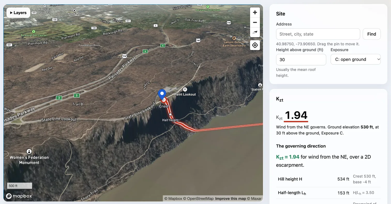
The Palisades are a line of cliffs along the west bank of the Hudson River, north of New York City. Take a house about 33 ft back from the cliff edge near State Line Lookout (40.9875° N, 73.9065° W), with a mean roof height of 30 ft, in Exposure C. The governing wind blows from the northeast, across the river and up the cliff. The numbers below come from the USGS elevation model through our topographic factor calculator, which shows the same site.
Step 1: the shape
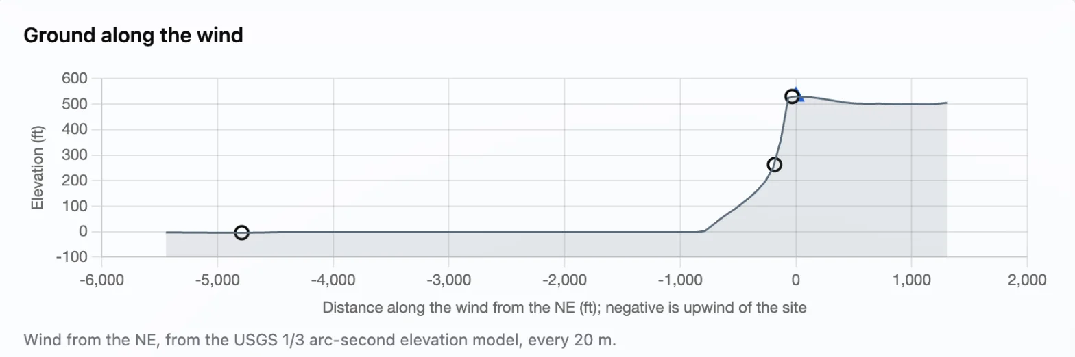
The ground rises from the river to the top of the cliff and stays high inland. That makes it a 2D escarpment, and the house is downwind of the crest.
Step 2: H, Lh and x
- The crest is at elevation 530 ft. The base is the river surface, at about −4 ft in the elevation model. H = 530 − (−4) = 534 ft
- The ground is at half height (H/2 = 267 ft above the base) 153 ft upwind of the crest, so Lh = 153 ft.
- The house is x = 33 ft downwind of the crest.
Step 3: the five conditions
- Isolated, and twice as high as upwind ground: upwind ground within 2 miles rises at most 114 ft above the base, under H/2 = 267 ft. ✓
- Near the crest of an escarpment: 33 ft back from the edge. ✓
- H/Lh = 534 / 153 = 3.5, at least 0.2. ✓
- H = 534 ft, at least 15 ft for Exposure C. ✓
One judgment call: ground to the side, within 2 miles, rises 366 ft above the base. That's the same line of cliffs running north and south, not a separate hill, so it doesn't make the cliff less isolated.
Step 4: the steep-slope rule
H/Lh = 3.5 is more than 0.5, so K1 uses H/Lh = 0.5, and K2 and K3 use 2H = 1,068 ft in place of Lh.
Step 5: K1, K2 and K3
K1 = 0.85 × 0.5 = 0.425
K2 = 1 − 33 / (4 × 1,068) = 0.992 (μ = 4 downwind of an escarpment)
K3 = e−2.5 × 30 / 1,068 = 0.932
Step 6: Kzt
Kzt = (1 + 0.425 × 0.992 × 0.932)² = 1.393² = 1.94
Velocity pressure is proportional to Kzt, so this house takes 94% more wind pressure than the same house on flat ground.
Kzt by height
Only K3 changes with height, so the speed-up fades higher up:
| Height z (ft) | K3 | Kzt |
|---|---|---|
| 15 | 0.966 | 1.98 |
| 30 | 0.932 | 1.94 |
| 50 | 0.890 | 1.89 |
| 100 | 0.791 | 1.78 |
| 200 | 0.626 | 1.60 |
K1 = 0.425 and K2 = 0.992 throughout.
Finding Kzt from elevation data
Reading H, Lh and x off a contour map by hand takes time, and has to be done for every wind direction. The topographic factor calculator does it from the USGS 1/3 arc-second elevation model, which has a point about every 10 m across the US:
- Click the site on the map, or enter an address. It samples the ground along 16 wind directions, 2 miles upwind of each crest.
- In each direction it finds the crest, the base (the lowest ground before the slope rises again), Lh and x. It then guesses the shape, which Pro accounts can change.
- It checks the five conditions and shows each one passing or failing, with the reason.
- It shows the ground profile with the crest, half height and base marked, so you can check what it found.
- The governing Kzt and the ground elevation, which the wind load needs for Ke, go straight into the wind load calculator.
Condition 2 says "in any quadrant". The calculator checks the ground upwind strictly. Rising ground to the side only shows a warning, because whether it's a separate hill or the same ridge, as in the example above, takes an engineer's judgment.
Frequently asked questions
What is Kzt on flat ground?
1.0. It's also 1.0 whenever any of the five conditions of section 26.8.1 isn't met.
How large can Kzt get?
At the crest of a steep 2D ridge in Exposure D, close to the ground: (1 + 1.55 × 0.5)² ≈ 3.2. Near the edge of a steep cliff, as in the example, it's about 2.
Is Kzt the same in every wind direction?
No. It depends on the ground the wind crosses, so each direction gets its own value. Design with the largest unless you check each wind direction on its own.
Did Kzt change between ASCE 7-16 and ASCE 7-22?
The method in section 26.8 and Figure 26.8-1 is the same in both editions.
What height z do I use for K3?
The height above the local ground at the building. For a low-rise building's roof pressures it's usually the mean roof height. Kzt is largest near the ground, so a lower z is the cautious choice.